Teledyne FLIR helps to keep airspace surrounding Swedish critical infrastructure free of drones

Teledyne FLIR successfully completed an installation of a long-range drone detection system for a critical
infrastructure site in Sweden. A smart slew-to-cue system, combining radar, thermal imaging and visual
sensors, makes sure no unmanned aircraft system goes undetected.

The FLIR Ranger HDC MR uses thermal imaging technology to detect threats in all conditions, including
nighttime, low-visibility, and poor weather such as fog, rain, and clouds.
As drones are becoming commercially available to a wider audience, effective drone detection and
monitoring has become increasingly important, especially for critical infrastructures and sites, such as power
plants, utility centers and airports.
However, effective and accurate drone detection is challenging. In contrast to land-based monitoring and
detection, aerial detection has a much wider, dome-shaped area to cover, with no real reference points. In
addition, today’s drones are fast and small, and they can demonstrate erratic flying behavior. Visual
detection systems have an additional challenge, in that they need to detect objects in variable sky and
weather conditions.
Drone detection for critical infrastructures
Teledyne FLIR recently provided a robust drone detection system for a Swedish critical infrastructure
customer. The project – completed early 2022 – was also made possible by Teledyne FLIR’s longtime
distributor and integration partner CCTV-Systems AB, a company which has been in the video surveillance
systems business since 1982. Just like Teledyne FLIR, CCTV-Systems AB has vast experience in providing
threat detection systems for industrial and security sectors all over the world.
Teledyne FLIR offered an integrated drone detection system based on radar and a combination of thermal
and visible sensors. The system uses a so-called slew-to-cue feature, where a radar will continuously scan
the sky, detect the drones from a long distance and automatically point the FLIR PTZ camera to the exact
position of the detected drone, whereupon the camera will continue to track the moving object using its
pan/tilt mechanism.

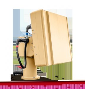
FLIR Ranger R8SS-3D radar can detect objects within a three-kilometer range and track up to 500 drone
targets simultaneously while effectively filtering bird detections.
Integrated drone detection system
“Today, Teledyne FLIR is the only company that can provide a total, integrated solution for this application,”
says, Johan Eklund, managing director at CCTV-Systems AB. “The company’s radar, dual thermal and
visible PTZ system, and software platform are all seamlessly integrated to provide a high-performance
surveillance system. And what’s more, all of the system’s components have been thoroughly tested and
proven in the field.”
“We are very fortunate to have such a dedicated and skilful partner in CCTV Systems AB,” says, William
Turner, Northern European sales manager at Teledyne FLIR. “In order to satisfy the complex requirements
of a demanding client, this project cut new ground and called for high levels of technical expertise and
customer commitment from Johan and his team.”

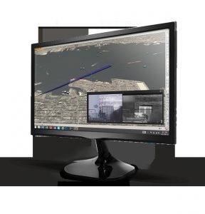
FLIR Cameleon software enables operators to control the surveillance system and share all detector
information with other agencies.
The system includes the FLIR Ranger R8SS-3D radar, which can detect objects within a three-kilometer
range and track up to 500 drone targets simultaneously, while effectively filtering bird detections. The
R8SS-3D provides complete hemispherical detection and is able to monitor the coverage area four times per
second, run 24/7, and detect all ground and aerial threats in virtually any climate, day and night.
Radar detections are continuously tracked with the FLIR Ranger HDC MR, a high-definition mid-range
surveillance system which uses thermal imaging technology to detect threats, even in conditions where
visibility is poor, at night or in degraded weather conditions, such as fog, rain and clouds. Everything the
system picks up is monitored through FLIR’s Cameleon software platform. This software enables operators
to control the surveillance system and share all detector information with other agencies.
Maximum detection accuracy
From the project onset the end-user’s minimum requirement was to obtain 100% accurate classification at
500 meters. Teledyne FLIR was able to far exceed this requirement thanks to thorough tuning and
calibration, and to the system’s superior optics and high-performance radar capability.
Teledyne FLIR also ensures that the system can operate with maximum uptime, not considered a luxury for
a critical infrastructure where 24/7 situational awareness is always needed. The system makes use of an
uncooled thermal sensor, which requires minimal maintenance leading to practically zero downtime. On the
other hand, a cooled camera would require periodic replacement of the cooling elements.
“This system is an ideal configuration for any critical infrastructure site that wants to keep its airspace free
from threats and that needs 24/7 decision-making support,” says, Eklund. “The system we installed in
Sweden could also be used as a reliable, mid-range drone detection system for airports, refineries, nuclear
plants, utilities and more.”
Find out more about Teledyne FLIR’s C-UAS solutions.
Comment on this article below or via Twitter @IoTGN
